-
Your shopping cart is empty!
Your shopping cart is empty!


The RYA Youth Sailing Scheme logbook provides an enjoyable and progressive way to learn to sail. Eac..

The C51 Cardigan Bay nautical paper chart includes the following plans;Pwellhi (1:12 500)Aberdovey (..

The C52 Cardigan Bay to Liverpool paper chart includes the following plans;Conwy (1:30 000)Conwy Bay..
 -24%
-24%
Imray chart C53 covers the north-west coast of Ireland from Donegal Bay to Rathlin Head, featuring a..
 -24%
-24%
The Imray C56 Cork Harbour to Dingle Bay nautical paper chart includes the following plans;Dingle Ha..
 -24%
-24%
The Imray C61 St George's Channel nautical paper chart covers the St George's Channel and Irish Sea ..

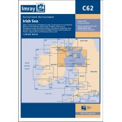
The C62 Irish Sea nautical paper chart includes the latest depth surveys throughout, firing practice..

The C63 Firth of Clyde nautical paper chart includes the latest depth surveys throughout, firing pra..
 -24%
-24%
The Imray C65 Crinan to Mallaig and Barra nautical paper chart includes the following plans;Castle B..
 -24%
-24%
The Imray C68 Cape Wrath to Wick and The Orkney Islands nautical paper chart includes the following ..
")
The standard reference to the waterways of England, Wales and Scotland has been completely revised. ..

The Irish Sea is a huge, almost landlocked sea. Around its shores and islands there are no fewer tha..

Admiralty NP259 Irish Sea, Eastern Part tidal stream atlas.1st Edition, 2006...


The Portland course plotter is used worldwide by practical and shore based instructors. A bright blu..